
Maxar has developed the Raptor navigation system for drones that works without GPS
31.03.25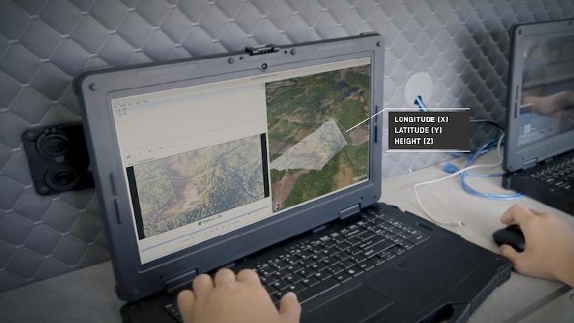
Maxar Intelligence has developed the Raptor system, which allows unmanned aerial vehicles to determine their location without GPS. The technology is based on the analysis of images from an on-board camera and their comparison with three-dimensional maps of the terrain.
The system includes three main elements: a module on the drone that processes data in real time, algorithms for comparing images with Maxar satellite maps, and an operator device that receives the drone’s precise coordinates.
The technology covers more than 90 million square kilometers of global 3D terrain data and can operate even in the dark. The company notes that Raptor expands the capabilities of autonomous systems, making it useful for both military and humanitarian missions, as well as for commercial applications.
Maxar Intelligence Director Peter Wilczynski emphasized that this development can change the approach to the use of drones in the defense and civilian sectors. Satellite maps are regularly updated, which updates can be carried out taking into account the needs of specific regions.
Don't miss interesting news
Subscribe to our channels and read announcements of high-tech news, tes
Oppo A6 Pro smartphone review: ambitious

Creating new mid-range smartphones is no easy task. Manufacturers have to balance performance, camera capabilities, displays, and the overall cost impact of each component. How the new Oppo A6 Pro balances these factors is discussed in our review.
Sony WF-1000XM6 Bluetooth headphones review: full power

The new Sony WF-1000XM6 headphones have slightly changed their shape compared to their predecessor, received a new processor, an improved noise cancellation system, more microphones, and generally made a noticeable step forward technically.
AI forms the financial preferences of users: which banks of Ukraine fall into the answers

The plusone AI agency has for the first time analyzed the extent to which Ukrainian banks are represented in the answers of popular AI models.
Two PCs in one case: Thermaltake Capo X is now on available

Thermaltake Capo X is a unique solution for users who need to place two independent computer systems in one case.