
Maxar has developed the Raptor navigation system for drones that works without GPS
31.03.25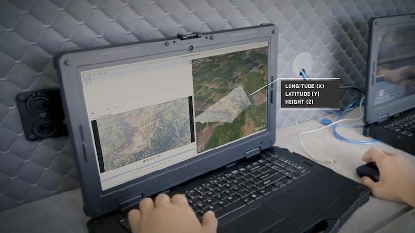
Maxar Intelligence has developed the Raptor system, which allows unmanned aerial vehicles to determine their location without GPS. The technology is based on the analysis of images from an on-board camera and their comparison with three-dimensional maps of the terrain.
The system includes three main elements: a module on the drone that processes data in real time, algorithms for comparing images with Maxar satellite maps, and an operator device that receives the drone’s precise coordinates.
The technology covers more than 90 million square kilometers of global 3D terrain data and can operate even in the dark. The company notes that Raptor expands the capabilities of autonomous systems, making it useful for both military and humanitarian missions, as well as for commercial applications.
Maxar Intelligence Director Peter Wilczynski emphasized that this development can change the approach to the use of drones in the defense and civilian sectors. Satellite maps are regularly updated, which updates can be carried out taking into account the needs of specific regions.
Don't miss interesting news
Subscribe to our channels and read announcements of high-tech news, tes
Oppo A6 Pro smartphone review: ambitious

Creating new mid-range smartphones is no easy task. Manufacturers have to balance performance, camera capabilities, displays, and the overall cost impact of each component. How the new Oppo A6 Pro balances these factors is discussed in our review.
Oppo Reno 15 5G smartphone review: confident

The Oppo Reno15 smartphone emphasizes design, a high-quality display, versatile cameras, and good battery life. Let’s take a closer look.
Microsoft adds image support to Notepad Microsoft update

Microsoft continues to expand the capabilities of the updated Notepad in Windows 11. The next step may be image support
ASUS and Acer stop selling laptops and operating websites in Germany due to Nokia’s victory in court Acer Asus court of law Nokia world events

In 2025, Nokia filed parallel lawsuits against Acer, Asus, and TV manufacturer Hisense at the Munich Regional Court and the Unified Patent Court.